Propose Innovative Solutions for Potential Collaboration
This Commercial Solutions Opening (CSO) contains broadly defined areas of interest. While some of these areas of interest are geared toward meeting requirements at listed locations, the Government reserves the right to award contracts from this CSO to meet ERDC-CERL requirements at other locations with similar areas of interest and mission requirements.
The CSO Solicitation document provides additional details and instructions.
Areas of Interest

Technology Area(s): data ingestion; conversion; inferencing; infrastructure; utilities; facilities; modeling; simulation; analysis; data fusion
Description: ERDC seeks to improve capabilities and methodologies for enabling users of an installation operations and planning tool to efficiently provide, transform and fuse legacy data sources (e.g., local standard data, non-standardized CAD or GIS files, map scans in PDF, legacy spreadsheets with numeric and text data, etc.) with modern data and analytics. Solutions should enable users to efficiently upload data from their local machine to a service available on an IL-4 government cloud-hosted service and have the solution detect the appropriate file types, categories, themes, and extract and populate metadata about the legacy data source. The solution should provide the ability to accurately and quickly transform the legacy data source into a hosted data store and format that preserves original source content and conforms to applicable standards (e.g., SDSFIE, BIM, etc.) as much as possible. The solution should preserve as much spatial information (e.g., latitude, longitude, height, elevation, dimensions, etc.) and textual information (e.g., identifiers, labels, materials, model numbers, etc.) as possible, and embed this information in the applicable files or fields. The solution may infer the meaning of labels within data based on label content and/or how labels are organized across data layers or files. The solution may infer facility footprints, walls, doors, windows, openings, and mechanical indicators. The solution may attempt to validate inferences if information from different sources is available (e.g., multiple files with varying information on the same facility or installation). The solution should attempt or aid in associating information across sources (e.g., mechanical data records and facility numbers from structured data sources, joined with spatial maps with facility numbers, and CAD records with facility mechanical locations). The solution may provide quality control/assurance processes, and should clearly demarcate data quality status (e.g., original, inferred, validated, etc.). Processed data will become part of an installation data representation. The solution should support user and administrator ability to manage appropriate data access controls and facilitate data discovery. Responses to this need may address all or portions of this description.

Technology Area(s): data fusion; data models; visualization;
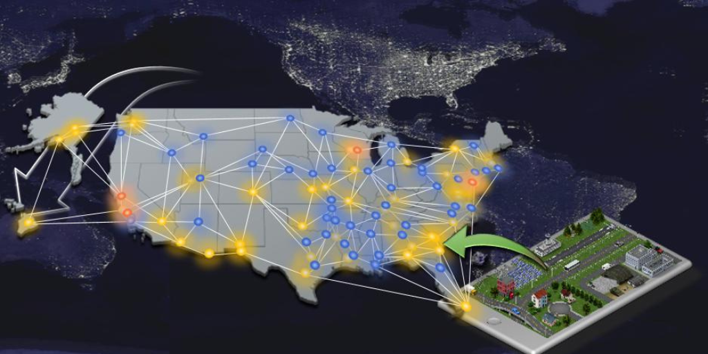
Description: ERDC seeks to provide robust installation representations for analysis, modeling, and visualization of past, present, and future conditions in order to improve military installation decision-making. An installation “Digital Twin” may include data models, and integrated analytical or visual models and simulations. An ideal installation “Digital Twin” would be compatible with or function as an IL-4 government cloud-hosted service. Visual capabilities would ideally support 3D and 2D, interior and exterior facility visualization, temporal selection and filtering, spatial selection and filtering, data querying and visualization of alternatives, and virtual reality fly-through and walk-throughs, as well as being able to scale and support visualizing a room interior, facility, or an entire installation. The ideal solution would support user creation of bookmarked locations, routes, and query sets, and enable users to create labels and other mark-ups, and potentially interact via an application programming interface (API) with editing tools, models, simulations, and other analytics. A preferred solution would support or be capable of supporting multiple data standards (e.g., SDSFIE), and file types and content (e.g., CAD/BIM, GIS, real-time sensors, etc.).
It is preferred that proposals include options for support to apply the capability to all or portions of at least two Army installations (i.e., the ERDC campuses, and another Army installation such as Fort Carson or Fort Benning, or others). Further, it is preferred that any capability that has per-unit license costs include not only a cost proposal and options for preliminary application, but also options and cost information for wider fielding, such as too many or all Army installations; potentially applicable pricing tiers may be based on total authorized or simultaneous users, square feet or number of facilities, or another approach as suitable to the capability. The preferred solution will be cost competitive for Army-wide fielding and include all necessary rights and licenses.

Technology Area(s): AI; ML; NLP; pattern analysis; collection; fusion
Description: ERDC seeks to improve installation activities and management through the application of artificial intelligence, machine learning, and advanced analytic technologies. There are numerous current Army data sources relevant to installations (e.g., HQIIS, RPLANS, ePRISMS, ASIP, BUILDER, ISR, GFEBS, ICE, etc.) and emerging sensors and other data sources that provide or will provide updated information on installation facilities, operations, maintenance, etc., and others that forecast future conditions, typically in a single domain.
ERDC seeks innovative solutions for better data management, collection, fusion, and processing to enable more rapid discovery, exploration, and understanding of patterns within and across the data. Solutions should be compatible with or function as an IL-4 government cloud-hosted service, and provide a robust Application Programming Interface (API) that enables integration with existing analytics and dashboards.
Solutions may address all or a portion of this topic, though preferably address multiple or all areas. This topic includes innovative data management solutions (i.e., data catalogs that assist in planning and managing data flows, serving metadata, tracking users and integrations, etc.), as well as artificial intelligence, machine learning pipeline and data exploration and visualization tools.
The ideal solutions will enable research or installation personnel to efficiently configure and implement processing pipelines that can inform dashboards created for installation end-users to gain and explore insights into topics such as operations, facility and other asset conditions, work orders, data quality, quality of life, environmental quality and condition, costs and investments, space assignments and utilization, visitor management, hazards, impact assessments, scheduling, and other topics relevant to installation activities. Other capabilities of an ideal solution would include the ability to explore potential interactions and courses of action, and assist users with: fusing data sources; understanding patterns, relationships, and correlations within the data; understanding uncertainty and confidence; documenting findings and alternatives. The ideal solution would support individual functional line and cross-functional pattern detection and support anticipatory and predictive insights. An ideal solution would support large volumes of diverse historical data (e.g., maintenance, facility, financial, etc.), as well as dynamic near-real-time data (e.g., weather, work order, utility, mechanical systems, etc.), and support a variety of data types (e.g., tabular, imagery, video, static & streaming, etc.).
It is preferred that proposals describe supported activities and required supporting data, and include options for supporting the application of the capability to all or portions of at least two Army installations (i.e., the ERDC campuses, and another Army installation such as Fort Carson or Fort Benning, or others). Further, it is preferred that any proposed solution that has per-unit costs include not only a cost proposal and options for preliminary application (e.g., dozens of research users and testers), but also options and cost information for wider fielding, such as for multiple or all Army installations and installation users. Potentially applicable pricing tiers may be based on total authorized or simultaneous users, square feet or number of facilities, or another approach as suitable to the capability. The preferred solution will be cost competitive for Army-wide fielding and include all necessary rights and licenses.

Technology Area(s): Sensors; AI; ML; pattern analysis; optimization; safety
Description: ERDC seeks proposals for innovative sensors that may be cost-effectively and securely added to military installations to improve or enhance installation activities–impacting the quality of life, sustainability, resilience, monitoring or compliance, and efficiency. The sensors should be able to communicate securely and be compliant with Army NETCOM requirements. Ideal solutions will describe proposed impacts to installation activities, be easy to install/retrofit and provide the government with open data access for integration with other analytics and processing capabilities. Sensor types of interest may be for detecting basic information such as temperature, humidity, motion, volume levels, or processed information such as the number of occupants, weapons, chemicals, gunshots, or other objects. Crowd-sourced or fused sensor/crowd-sourced solutions may also be considered. Sensors with streamlined and testable workflows for training new items are of interest. The ideal solution would be compatible with an IL-4 government cloud-hosted service and be able to be integrated as part of a Common Operating Picture dashboard.
It is preferred that proposals include options for support to apply the capability to all or portions of at least two Army installations (i.e., the ERDC campuses, and another Army installation such as Fort Carson or Fort Benning, or others). Further, it is preferred that any capability that has per-unit costs include not only a cost proposal and options for preliminary application, but also options and cost information for wider fielding, such as for a complete facility, installation, or multiple or all Army installations. Potentially applicable pricing tiers may be based on the number of sensors, users, covered square feet or facilities, or another approach as suitable to the capability. The preferred solution will be cost competitive for Army-wide fielding and include all necessary rights and licenses to support integration with existing government software.

Technology Area(s): smart and resilient installations; urban planning, regional planning, digital installation, quality of life, behavioral analytics, smart islands,
Description: As the world inside and outside Army military bases becomes increasingly interconnected and technology-enabled capabilities, the Army requires adaptation of policy, processes, and infrastructure, and Installation Master Planning is recognized as offering a smart city context to enable the business transformative objectives outlined in the Army Installation Strategy (AIS), Army Data Strategy (ADS), and the Army Business Management Plan (ABMP 2021-2025). The Army is sponsoring initial business transformative and modernization pilots addressing the Installation Master Planning process through the development of a next-generation comprehensive installation planning common operating picture (COP) to digitize planning and programming processes integrated with a GIS-based platform to consolidate, analyze, and visualize GIS, IoT, Army legacy and installation data and future development alternatives to enable near-real-time short- and long-term decisions for real property, infrastructure, environment, mobility, quality-of-life, operations, mission, and security and safety. To enable at scale, the Army wishes to further explore digital twin solutions and partnerships with innovative small businesses for solutions to smart installations and urban planning challenges. The areas listed below are general functions that the Army is interested in leveraging novel solutions in support of:
- Army Installation Planning Common Operating Picture (COP) campaign plan to deploy, test, and train the minimum viable product which will be available Feb 2022.
- Enterprise consumption, for example, solution development using master planning data for digital enterprise views of resource impacts based on master planning scenarios and/or projects.
- Advanced Modeling Scenarios, for example, integrate from a growing portfolio of urban planning COTS and open source tools developed by contributors from academia, planning organizations, businesses, and individuals to integrate seamlessly with one another and focus on the specific problems encountered when performing spatial analysis within cities such as transportation planning, climate preparedness, population synthesizers, and others. Several urban planning open source software are free or low-cost acquisition.
- Lifecycle forecasting of Smart Assets, for example, exploring planning cost and timeline forecasting techniques leveraging machine learning/artificial intelligence (ML/AI) where benefits can result from using limited or imperfect data to de-bias decisions.
- Quality of Life, for example, stakeholder engagement is limited based on underserved outreach or space limitation of installation master planning charrettes. To capture feedback from civilians, soldiers, and their families, leverage web-based customizable stakeholder engagement platforms to engage stakeholders and capture geo-location feedback on the existing and proposed changes, to reach better QOL planning outcomes.
- Mobility features, for example, a right-size application for mobile/tablet use in the Army environment for data collection, validation, and visualization in the field.
Solutions shall be tailored to support UFC 2-100-01 Installation Master Planning and relevant Army pamphlets and regulations except where data-driven evidence requires a request for policy update to fulfill the driving Army guidance and mandates for modernization and innovation.
The Army is interested in exploring innovative technology domains that may not be covered in the list above, so this topic is intended to also be a call for open ideas and technologies that cover other related areas not currently listed (i.e. the unknown-unknown). This topic is meant for innovative solutions to be adapted in innovative ways to meet DoD stakeholders’ needs in a short timeframe and at a low cost.
ERDC-CERL will typically use a one-step evaluation process but does reserve the right to request a pitch (see CSO Solicitation) that would add a second step to the evaluation process. Under the one-step evaluation process, offerors whose proposed solutions meet the need of the government and include enough detail to complete a full technical evaluation will not be required to provide a pitch of their solution.
All contracts will be firm-fixed price. All supplies and services procured via this CSO are treated as commercial. The Contracting Officer must determine the price fair and reasonable prior to award. ERDC-CERL is conducting this CSO on a full and open basis and intends to award contracts in accordance with FAR part 12 and the FAR part that is deemed most appropriate for the solution proposed (i.e. FAR part 13, 15, and/or 35); the government reserves the right to award agreements (e.g. Other Transaction Agreements), if deemed in the government’s best interest.
How to Participate
- Review the CSO Solicitation
- Review general CSO FAQs
- Once the solution is ready to submit, complete the submission form
Questions: Please send all technical and administrative questions using this form. FAQs will be updated periodically. It is the responsibility of the offeror to review FAQs prior to submitting a proposal.